GIS in ecology презентация
Содержание
- 3. Aim demonstrate the benefits of GIS technologies application in environmental projects.
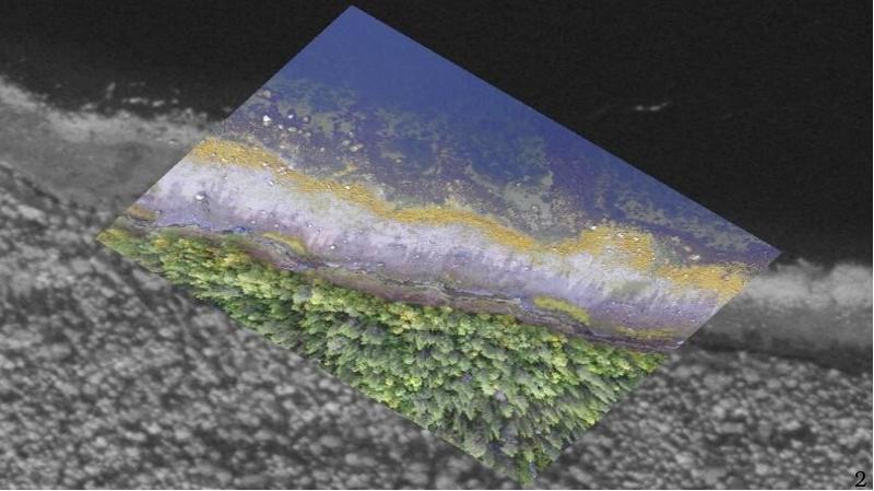
- 4. GIS contain information on the spatial distribution of the data.
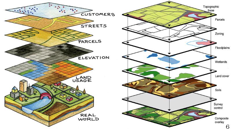
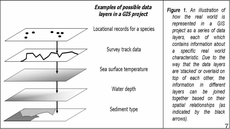
- 5. How data is organised in GIS How data is organised
- 8. The creation of GIS helps in the formulation of hypotheses for
- 9. GIS calculations with using the formula of vegetation indices - NDVI,
- 10. New variables can also be calculated using GIS in that aspect
- 11. GIS can be used to link data as needed for statistical
- 12. GIS is useful in the display of data because it provides
- 13. To summarize or why we use GIS in ecology: The creation
- 14. Conclusion The potential use of GIS systems now far goes beyond
- 15. List of references Tomáš VÁCLAVÍK. Master‘s Thesis: «The Use of GIS
- 17. Скачать презентацию


Слайды и текст этой презентации
Слайд 1
Описание слайда:
GIS in ecology
Prepared by Kuchinskaia E.S.
Group: E-M19-1-9
Checked by Fedorova N.Y.
Слайд 2
Описание слайда:
Слайд 3
Описание слайда:
Aim
demonstrate the benefits of GIS technologies application in environmental projects.
Objectives
review the mechanisms of GIS
reveal the possibilities of using GIS in ecology
formulate the reasons why the use of GIS is beneficial in the environmental issues management
Слайд 4
Описание слайда:
GIS contain information on the spatial distribution of the data.
GIS contain information on the spatial distribution of the data.
Слайд 5
Описание слайда:
How data is organised in GIS
How data is organised in GIS
Spatial information is held in the GIS as a series of data layers
Слайд 6
Описание слайда:
Слайд 7
Описание слайда:
Слайд 8
Описание слайда:
The creation of GIS helps in the formulation of hypotheses for tests or to make new suggestions for ecological exploration.
Слайд 9
Описание слайда:
GIS calculations with using the formula of vegetation indices - NDVI, GNDVI and NDWI, Erkil crushed stone quarry, scale 1: 15000
Слайд 10
Описание слайда:
New variables can also be calculated using GIS in that aspect and the slope of topography from altitude and elevation information can be achieved.
Слайд 11
Описание слайда:
GIS can be used to link data as needed for statistical analysis.
Слайд 12
Описание слайда:
GIS is useful in the display of data because it provides essential information on collection of the data.
Слайд 13
Описание слайда:
To summarize or why we use GIS in ecology:
The creation of GIS helps in the formulation of hypotheses for tests or to make new suggestions for ecological exploration.
GIS can be used for making measurements and carrying out calculations that would have been harder to achieve.
New variables can also be calculated using GIS in that aspect
GIS can be used to link data as needed for statistical analysis.
GIS is also useful in the display of data because it provides essential information on collection of the data.
Moreover:
GIS technology allows you to receive and analyze data from remote and inaccessible regions.
GIS technologies allow the free use of data more than 20 years ago and guarantee their reliability.
Allows you to increase the speed of analysis of the studied objects, reduces physical and time costs.
Various calculation methods in geographic information systems allow you to analyze territories of any scale and nature.
They provide relatively high accuracy of the results and with the improvement of GIS systems this accuracy will steadily increase.
Слайд 14
Описание слайда:
Conclusion
The potential use of GIS systems now far goes beyond its technical implementation. However, while GIS technology greatly enhances decision-making capabilities, it does not replace them. In a sense, it is both a “ toolbox” of advanced analysis capabilities and a “sandbox” for visual presentation of the results. Although GIS technologies represent an efficient technical tool for deliberate regional planning, it requires a certain technical level of the user. Nevertheless, as it was shown, GIS systems in ecology are quite useful, and learning how to use GIS programs is not as difficult as it might seem.
Слайд 15
Описание слайда:
List of references
Tomáš VÁCLAVÍK. Master‘s Thesis: «The Use of GIS in Ecological Planning»
Шибалова Г.В. Возможности применения дистанционного зондирования для сбора информации о нарушенных землях //Природообустройство, 2010. № 4. С. 14-18.
Черепанов А.С., Дружинина Е.Г. Спектральные свойства растительности и вегетационные индексы //Геоматика, 2009. № 3. С. 28-32.
Никола М. Трендов, Самуэль Варас и Мэн Цзэн. Цифровые технологии на службе сельского хозяйства и сельских районов. Продовольственная и сельскохозяйственная организация Объединенных Наций, Рим, 2019 год
Internet resource: «EarthExplorer» - https://earthexplorer.usgs.gov/
Internet resource: «GIS in Ecology» - http://gisinecology.com/
Internet resource: «GIS innovation center». GIS Usefulness In Ecology - http://www.gistic.org/gis-usefulness-in-ecology/
Слайд 16
Описание слайда:
Скачать презентацию на тему GIS in ecology можно ниже: