Status of Norwegian Sea Borders презентация
Содержание
- 2. Norwegian Mapping and Cadastre Authority
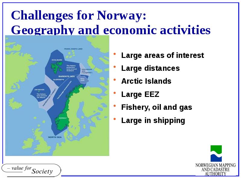
- 3. The Artic Challenge 25 % of the world’s oil and gas
- 5. Sea Border - Responsibility Norwegian Ministry of Foreign Affairs on behalf
- 6. Norway-status of sea borders Existing Sea Borders Norwegian mainland Spitsbergen Jan
- 8. Field Work in 1970 and 1980’s
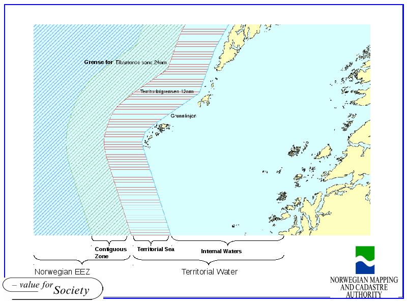
- 9. Sea Area statistics per Nov. 2007 Including Norwegian mainland, Spitsbergen and
- 10. Norwegian Sea Borders-determination Borders between Denmark/Greenland and Norway (Jan Mayen and
- 11. Norwegian Sea Borders-comments Unsolved towards Russia Principle for “delimitation line” equal
- 12. Other requests for borders Norwegian Customs has asked for 250nm borders:
- 13. Access to Sea Borders dataset Base line available for everyone official
- 14. Users Requests for sea borders from: Fishery Shipping Coast guard The
- 15. Overall Data model for Norway Specification Management and Updating procedures Prepared
- 16. Norwegian Sea Borders data model Version 1 in 2007 Sea Border
- 18. Thanks for your attention
- 19. Скачать презентацию


Слайды и текст этой презентации
Слайд 1
Описание слайда:
Status of Norwegian Sea Borders
SBE Core team meeting
13-14 November 2008
Brede Gundersen
[email protected]
Слайд 2
Описание слайда:
Norwegian Mapping and Cadastre Authority
Слайд 3
Описание слайда:
The Artic Challenge
25 % of the world’s oil and gas reserves might be in Arctic Zone
Increased traffic in air and on water crossing the poles
Increased need for environmental inspection
etc.
Слайд 4
Описание слайда:
Слайд 5
Описание слайда:
Sea Border - Responsibility
Norwegian Ministry of Foreign Affairs
on behalf of the Government, negotiate and make agreements upon the borders to neighbouring countries
Statens kartverk
through Geodetic Institute
survey and calculate the base lines and other points/lines derived
Data is uploaded into the database
Statens kartverk is the owner of the border data
coordinates and attributes
Слайд 6
Описание слайда:
Norway-status of sea borders
Existing Sea Borders
Norwegian mainland
Spitsbergen
Jan Mayen
Bouvet Island (54˚ South)
Delimitation lines:
agreed with Sweden, Denmark, Iceland, UK
Under negotiation with Russia
Norway has claimed extension of Continental Shelf and EEZ according to UNCLOS article 76
Scientific proof to Commission on the Limits of the Continental Shelf no later than 13th May 2009
Слайд 7
Описание слайда:
Слайд 8
Описание слайда:
Field Work in 1970 and 1980’s
Слайд 9
Описание слайда:
Sea Area statistics
per Nov. 2007
Including Norwegian mainland, Spitsbergen and Jan Mayen
Internal Waters 125,313 km2
Territorial Sea 114,701 km2
Territorial water 240,014 km2
EEZ 1,878,961 km2
Continental Shelf 2,127,192 km2
The statistics are based on:
1. Norway’s claim to the Commission on the Limits of the Continental Shelf
2. the calculated “equal distance line” between Norway and Russia; the delimitation line is under negotiation
Слайд 10
Описание слайда:
Norwegian Sea Borders-determination
Borders between Denmark/Greenland and Norway (Jan Mayen and Svalbard)
Each country calculated the “equal distance line” by use of specialised SW
Commercial (e.g. CARIS)
Norway-special developed SW
Small differences=agreed sea borders
Слайд 11
Описание слайда:
Norwegian Sea Borders-comments
Unsolved towards Russia
Principle for “delimitation line”
equal distance line
sector line
Borders agreed before ETRS89/EUREF existed towards Sweden, Denmark and UK :
Protocol/treaties shows coordinates in ED50
Transformation to ETRS89 is not formalised/agreed
Слайд 12
Описание слайда:
Other requests for borders
Norwegian Customs has asked for 250nm borders:
tax for emission of nitrogen
Norwegian requirements only?
Слайд 13
Описание слайда:
Access to Sea Borders dataset
Base line available for everyone
official web-pages
Sea Borders
Norway Digital partners
Downloading from web
Other users
Through state-distributor (NE)
As SOSI- and shape-files
charged
Prepare downloading from our geoPortal
later this year – 2008?
Free of charge (?)
Слайд 14
Описание слайда:
Users
Requests for sea borders from:
Fishery
Shipping
Coast guard
The Military Map Service
Customs
etc
Слайд 15
Описание слайда:
Overall Data model for Norway
Specification
Management and Updating procedures
Prepared for land borders between Norway and Sweden
Слайд 16
Описание слайда:
Norwegian Sea Borders data model
Version 1 in 2007
Sea Border Database is populated
Coordinates mostly, few attributes
Data model to be updated
Municipal boundaries
Connecting points (data model)?
Crossing of pipelines (Petroleum Industry is using ED50)
Слайд 17
Описание слайда:
Слайд 18
Описание слайда:
Thanks for your attention
Скачать презентацию на тему Status of Norwegian Sea Borders можно ниже: